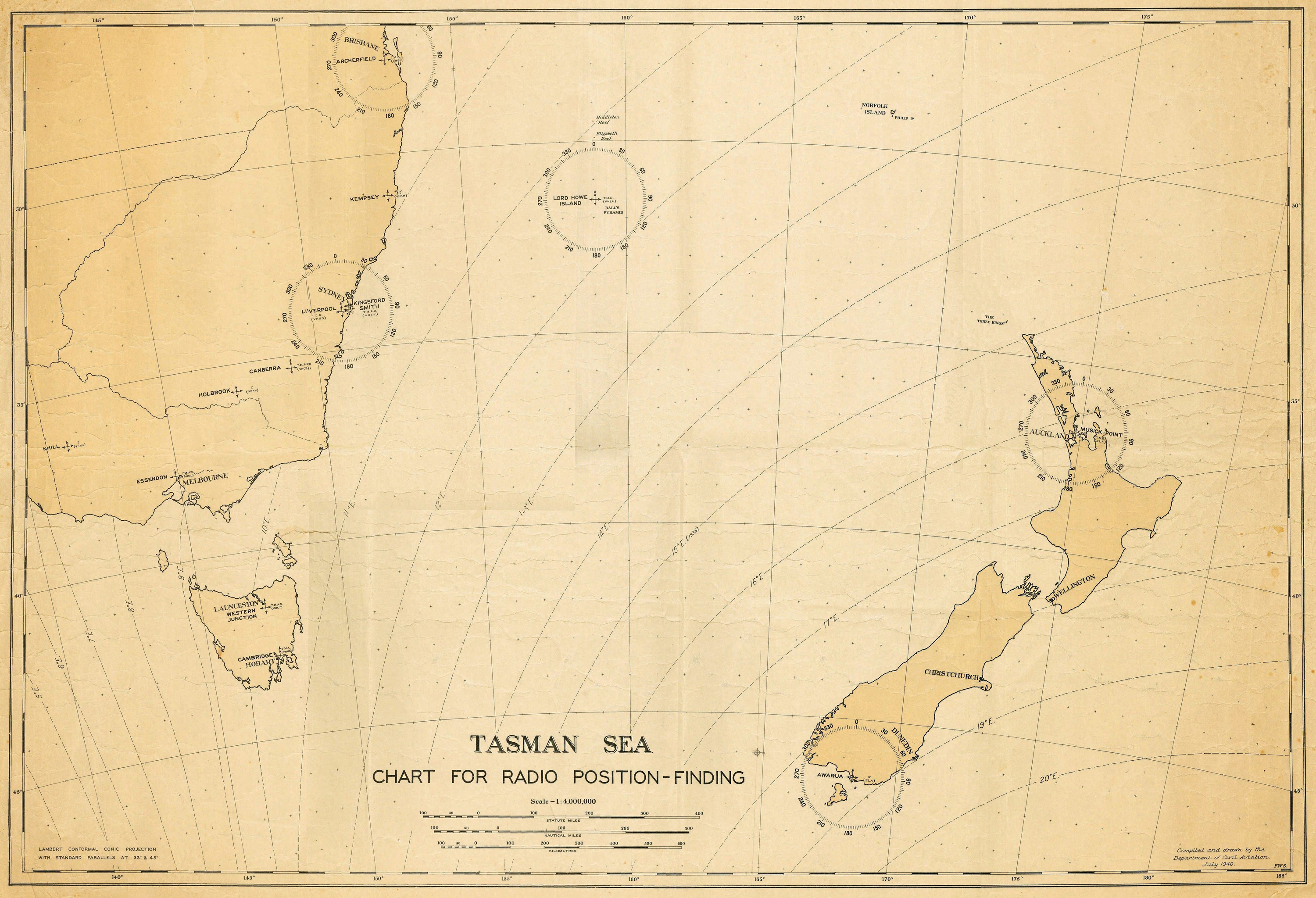
Tasman Sea Chart for Radio Position-Finding [Copy]
Digital Image
Identifier: D27620001
Untitled
Dates
- July, 1940
Creator
- Department of Civil Aviation (Compiler, Organization)
Conditions Governing Use
This item has no known copyright restrictions. Please reference Invercargill City Libraries and Archives A0107 S27620001 when re-using this image.
Existence and Location of Copies
To obtain a high resolution copy of this image please contact the Archive.
Physical Description
Copy on durable poster paper.
Map Notes
Lambert Conformal Conic Projection with Standard Parallels at 33 degrees and 45 degrees.
Stations: Awarua, Musick Point, Liverpool, Kingsford Smith, Kempsey, Archerfield, Lord Howe Island, Essendon, Nhill, Holbrook, Canberra.
Stations: Awarua, Musick Point, Liverpool, Kingsford Smith, Kempsey, Archerfield, Lord Howe Island, Essendon, Nhill, Holbrook, Canberra.
Complimentary resource to Awarua Radio publication
Refer to 'Awaraua Radio ZLB 1913 - 1991' by Alex C. Glennie (published 2018). Library ref: LC 384.5453 GLE
This Radio Position-Finding Chart can be used in conjunction with the above publication to better understand both the chart's use and purpose in radio direction finding, as well as enhance the reading of the publication.
Mr. Glennie has indicated parts in the above publication relevant to radio direction finding. Refer to the following pages and/or page scans available via Archives staff. Pages: 27, 32, 34 - 37, 39, 42 - 43, 45 - 47, 109, 117, 120, 193, 202 - 203, 310 - 313, 316 - 317. Mr. Glennie is also happy to be contacted regarding his research.
For further information on Radio Direction Finding refer to:
http://www.awaruamuseum.co.nz/awarua-radio/direction-finding.html
https://www.britannica.com/technology/radio-direction-finder
https://en.wikipedia.org/wiki/Radio_direction_finder
https://en.wikipedia.org/wiki/Direction_finding
Creator
- Department of Civil Aviation (Compiler, Organization)
Repository Details
Part of the Invercargill City Council Archives Repository
Contact:
50 Dee Street
Private Bag 90111
Invercargill Southland 9810 New Zealand
archives@icc.govt.nz
50 Dee Street
Private Bag 90111
Invercargill Southland 9810 New Zealand
archives@icc.govt.nz
